 From the Massachusetts Emergency Management Agency:
Please see the attached forecast bulletins from the National Weather Service offices in Albany and Norton concerning the high temperatures and heat indices today and the potential for strong to severe thunderstorms this afternoon and evening.
From the National Weather Service in Norton:
Hot and humid conditions are on tap today with our first taste of excessive heat this summer season as heat indices will range from 95-103°F for interior areas of S New England.
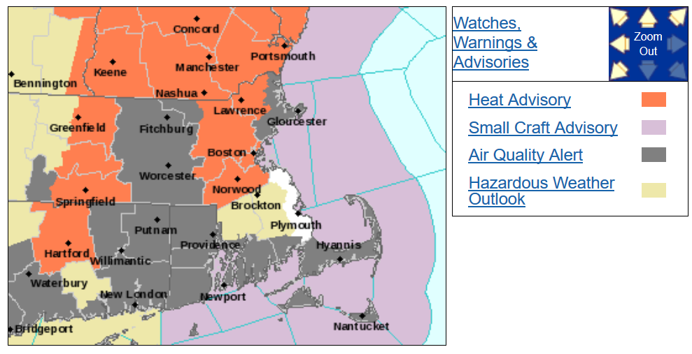
- HEAT ADVISORIES posted which have been expanded to include the city of Boston and surrounding metro-area, as well as the mid CT River Valley.
This in addition to the potential for strong to severe thunderstorms this afternoon into evening with embedded threats of cloud to ground lightning, strong to damaging winds, and/or brief heavy rain.
- There is presently a MARGINAL to SLIGHT RISK for scattered strong to severe thunderstorms, mainly over northern and western areas of MA and CT.
- There is also a MARGINAL RISK for excessive rainfall over northern and western areas of MA.
Watches, Warnings and Advisories
|
||||
|
||||
|
||||
|
||||
MEMA Operations
The State Emergency Operations Center (SEOC) at MEMA Headquarters in Framingham is currently operating at Level 1 (Steady State Monitoring). MEMA will continue to monitor the forecast and will disseminate Situational Awareness Statements as necessary.
Preparedness and Safety Information
Thunderstorm and Lightning Safety Tips: https://www.mass.gov/service-details/thunderstorm-and-lightning-safety-tips
Extreme Heat Safety Tips: https://www.mass.gov/service-details/extreme-heat-safety-tips
Tornado Safety Tips: https://www.mass.gov/service-details/tornado-safety-tips
Stay Informed
Utilize Massachusetts Alerts to receive emergency notifications and information from the Massachusetts Emergency Management Agency and the National Weather Service. Massachusetts Alerts is a free app that is available for Android and iPhones. To learn more about Massachusetts Alerts, and for information on how to download the free app onto your smartphone, visit: https://www.mass.gov/service-details/massachusetts-alerts-smartphone-app.
Utilize MEMA’s real-time power outage viewer to stay informed about current power outages in your community and region, and across the state, including information from utility companies about restoration times:https://mema.mapsonline.net/public.html
Utilize MEMA’s live weather radar and forecasting tools: https://www.mass.gov/map-resources
Online Resources
Massachusetts Emergency Management Agency at www.mass.gov/mema
MEMA’s Facebook page: https://www.facebook.com/MassachusettsEMA
MEMA Twitter: @MassEMA
Federal Emergency Management Agency at www.fema.gov
National Weather Service/Norton at www.weather.gov/boston
National Weather Service/Albany, NY at www.weather.gov/albany
National Weather Service Weather Prediction Center: https://www.wpc.ncep.noaa.gov
National Weather Service Storm Prediction Center: https://www.spc.noaa.gov/
Mass211 at www.mass211.org
